Qohaito - an Ancient City |
|
Qohaito was a pre-Aksumite city that thrived during the Aksumite period. It is located over 2,500 meters above sea level in the Debub region of Eritrea. The ancient port of Adulis lies directly to the east of Qohaito.
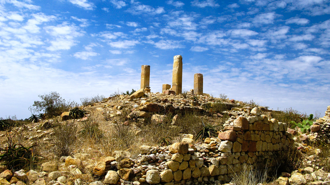
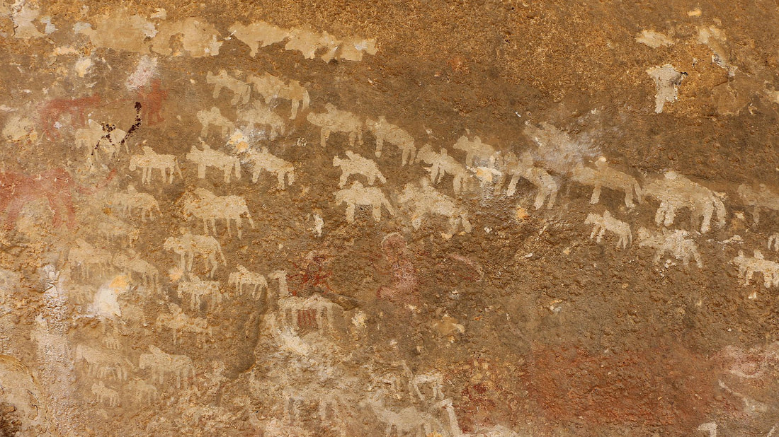
Eritrea has one of the highest densities of archaeological sites Known in Africa with an estimated 8,000 belonging to different periods. Some of Eritrea’s archaeological sites such as Adulis, Metera, Qohaito, Dahlak Khebir and the recent historic sites of Nakfa are declared as world heritage. Yet only a few of the sites have been subject to more than cursory investigation and research. Here, we look at Qohaito – one of the most significant sites in Eritrea. THE CITY OF QOHAITO Only a small part – about 20% – of the ruins of Qohaito has been excavated so far but what you see in the area now is large enough to give you a glimpse of how big the area may have been when it stood as a city. The four columns and assorted rubble of the Temple of Mariam Wakiro, an early Christian church, are surrounded by the dusty remains of other temples. To the north of the site is a sandstone-hewn Egyptian Tomb. The underground tomb, known as Meqabir Ghibsi (Egyptian Tomb), is located east of Weiro Omyiler with its rectangular shape curving out of the rock and is surrounded by huge blocks of stones. Inside the tomb, there are two quadrifoil crosses on two walls facing each other. Nearby, are several rock-art sites, including the cave of Adi Alauti and another shelter with over 100 painted figures. With 750 sites identified so far, the site of Qohaito comes complete with column constructions, dams, cisterns, cemeteries and various other trappings of a proper city. The biggest construction in Qohaito, in terms of its historical significance and size, is the beautifully dressed masonry of Safira Dam. The dam is over 60m long and is believed to date back to 1000 years. It is built of large blocks of stones and has a large concentration of ancient small sized houses with narrow streets all along. Though it is clear there were other dams as well, today only Safira dam, which still serves the local population as their main water source, exists. Legend has it that the Queen of Sheba bathed in the dam on her way to Axum. At about 400 meters Southeast of Safira are many structures with the cisterns, wide streets, and large houses believed to be the residence of the wealthy elites of Qohaito. Research is ongoing to determine whether this part of Qohaito represented the site of temples or secular buildings. This part of the city is known as Weiro Omyiler – the abode of the rich and great. AWALU GUDA The Awalu Guda plateau is located approximately 2km north of the town of Adi-Qeyih and about 4km west of Qohaito. It is found at the point where the Hischmele valley and Himbrten canyon meet. This rock shelter measures three meters deep and has a length of 12metres. According to documents at the National Museum of Eritrea (NME), the floor of the rock shelter contains a dense concentration of ceramic shards, many of which resemble grey/black Aksumite earth wares. This cave has also elaborate pictographs in red, white and black that show the nomadic life of ancient people in the area. Leopards, camels, lions, horses, hyenas, antelopes, giraffes and longhorn cattle and possibly human-like figures are depicted on the walls. In addition to the pictographs, a petroglyph inscription is visible on the northern side of the rock shelter wall. |

|